A Brief history of the Village
We are greatly indebted to Vicky Airey who has provided most of the
information for this page. Vicky hopes to publish a more complete history
of the village at some time.
Introduction | The Manor |
Pisford's Charity | Butchers etc |
Smithy
Customs | Dialect words |
Place names | Buildings |
1918 on

An aerial view in 1987
Bubbenhall
The village is situated
along the boundary formed by the River Avon between the Forest of Arden
to the north and west and the more open area of Feldon to the south and
east. Bubbenhall therefore includes characteristics of both Feldon (with
the open-field system) and Arden (primarily forest). Waverley Wood to
the south-east, however, is known to be the relic of a much larger wood
called Echills which marked the eastern boundary of the Forest of Arden.
The earliest recorded instance of the name of the village is "Bubenhalle"
in Domesday Book (1086). This shows that the village existed for some
time before 1086 although no documented evidence has been found. The most
likely explanation for the place name is that it means Bubba's Hill. Bubba
is a fairly well recorded personal name in Anglo-Saxon times.
In 1086 there was a mill worth 4/-, woodland which was 2 furlongs long
and two furlongs wide (presumably some 40 acres), and the whole village
with an area of 5 hides (600-1200 acres) was worth 50 shillings.
Bubbenhall was in the hundred of Stoneleigh but this was later incorporated
into the hundred of Knightlow.
Agricultural Development
The map of Bubbenhall before the new housing estates began to be built
in the 1970s, shows the medieval pattern of a row of cottages and farmhouses,
each with a croft or close, extending from opposite the Spring ("the
Spout") down to the bottom of the village. Above the Spring was the
Green, which was enclosed and ploughed up during the Second World War.
Among the main early village farms were Cross House (now known as the
Manor House) in the middle of the village (opposite a small green, taken
away about 1930), Yew Tree Farm, the Home Farm (probably previously The
Moat), Old House Farm, and Church House Farm (probably the prebendal grange).
Parliamentary enclosure of the old open fields - Grove Field and the Harps
to the SE, Ludgate Field to the NE, and Cloud Field to the W took place
in 1726 (which was the second earliest in Warwickshire). The land was
divided among the different manorial tenants and two major new farms were
built with surrounding blocks of land belonging to them. These were Wood
Farm, built some time before 1809, and Waverley Wood Farm, probably in
embryonic form in 1809. Otherwise the old centrally situated farm buildings
were still in operation, but had rationally organised blocks of land belonging
to them; eg. Yew Tree Farm, belonging to William Paget, had land in Paget's
Lane.
In the late 19th and early 20th centuries several sales by auction took
place, and farms and land changed hands. This was an opportunity for tenant
farmers to become owners of land and farmhouses. With the breaking up
of the Baginton Estate in 1918 people were able to buy these houses and
cottages for the first time. At the same time the stability of leaseholds
which often passed from generation to generation in the old village families
ended.
The Old School
In the 18th century charity schools were established at Stoneleigh and
Cubbington, with some places for Bubbenhall children. In the early 19th
century the school which was established at Baginton also took Bubbenhall
children. However, less than half of the 70 to 80 school age children
of Bubbenhall were able to go to school in the 1860s. In 1864 the Rector
managed to establish a village school in Bubbenhall, which continued until
it was closed down in 1999.
| Year | Population | Houses |
|---|
| 1665 | 157 | |
| 1730 | 150 | |
| 1801 | 261 | |
| 1811 | 261 | 32 |
| 1821 | 247 | 59 |
| 1891 | 234 | |
| 1931 | 291 | |
| 2011 | 655 | 280 |
| 2021 | 650 | 270 |
Population
In 1665 there were 157 people in the village and in 1730 there were still
about 150. By 1801 the population had increased to 261. In 1811 there
were 32 houses and the same population of 261 - about 8 people in each
house. In 1821 there were 59 houses with 247 people - about 4 people in
each house; a remarkable change in fortunes. In 1888 the area of Bubbenhall
was 1114 acres. By 1891 the population was slightly less at 234 and the
area of the parish was 1290 acres. In 1931 the population was 291; there
were still 2 public houses, a miller, a butcher and a shop and post office.
Today the population is 650 (according to the 2021 census).
The Manor
The Domesday Book entry of 1086 records Bubenhalle as a manor in the hundred
of Stoneleigh, owned by Robert de Stafford. In the manor there were 6
villagers, and 2 smallholders with 2 1/2 ploughs, and 1 1/2 ploughs and
one serf in the lordship, held "freely" by Aelfric. A ploughland
or carucate was in effect the amount of arable land that could be managed
by a caruca or plough, and the beast belonging to it, per year. Therefore
the number of ploughs is a description of the amount of arable land (though
this is obviously variable according to type of soil, lie of the land,
etc.).
In 1420 the lord of the manor, John Beauchamp, was created a baron by
Richard II
In 1460 the lord of the manor was the Duke of Buckingham
A separate manor existed until 1717, when Bubbenhall became a joint manor
with Baginton under the lordship of the Bromley family (subsequently the
Bromley-Davenport family, when the Bromley line died out and these manors
went to cousins.). The whole estate was then sold up in 1918.
It is possible that The Moat, latterly divided into two cottages, in Lower
End (demolished about 1970), was originally a moated farm or the manor
house. Some time after 1809 the present Top House the last large old house
on the left-hand side going out of the village on the main road to Ryton
- appears to have been built as the Home Farm of the manor of Bubbenhall.
Link
with Pisford's Charity in Coventry
William Pisford was a grocer, Mayor of Coventry in 1500, and founder of
the almshouses known as Ford's Hospital, Coventry. In 1528 William Wigston
purchased five cottages and land in Bubbenhall as a form of endowment
for the almshouses. These were the cottages, now mainly rebuilt or extended,
starting next to the Three Horse Shoes and continuing down that side of
the centre of the village, as far as and including The Cottage. They belonged
to Ford's Hospital until the late 19th century. The charity was also endowed
with lands in Coventry, Foleshill, Keresley and Weston under Wetherley.
Butchers, Bakers, Shoemakers, etc.
There was a village butcher's shop at the top of Church Road from at least
the 1840s onwards. The premises were owned, until 1918, by the Lord of
the Manor. The shop was latterly run by Dennis Ruck and continued until
about 1990.
Village bakers, like the post office, have had various different locations
in Bubbenhall. In the late 19th century, for instance, both were run from
The Cottage in the middle of the village. Around 1950 the Post Office
was at The Hollies, but there was no bakery any more, and bread was delivered
to the village by van, as was fish. There was also an ironmongery van,
and a fish-and-chip van.
The last shoemaker in Bubbenhall was William Abbey, who lived at the Bottom
End.
Craftsmen into the 19th century were often part-time farmers, and some
were carriers of goods from Coventry.
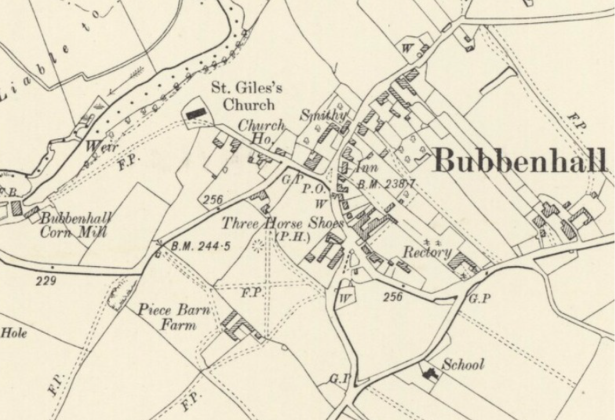
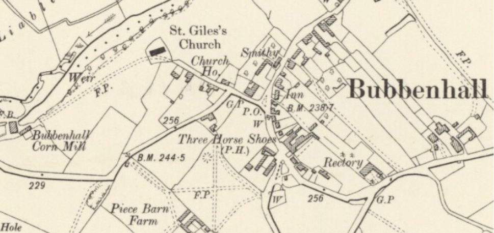
Smithy
The last smithy was opposite the Malt Shovel. Earlier, though, there were
several other smithies, including one in the 18th century sited near what
became the Three Horseshoes.
Customs and traditions
There were many opportunities for merry making in the village.
There was a May Day Procession of children from the school, with a May Queen dressed in white
and a floral arch. This event continued until the 1950s.
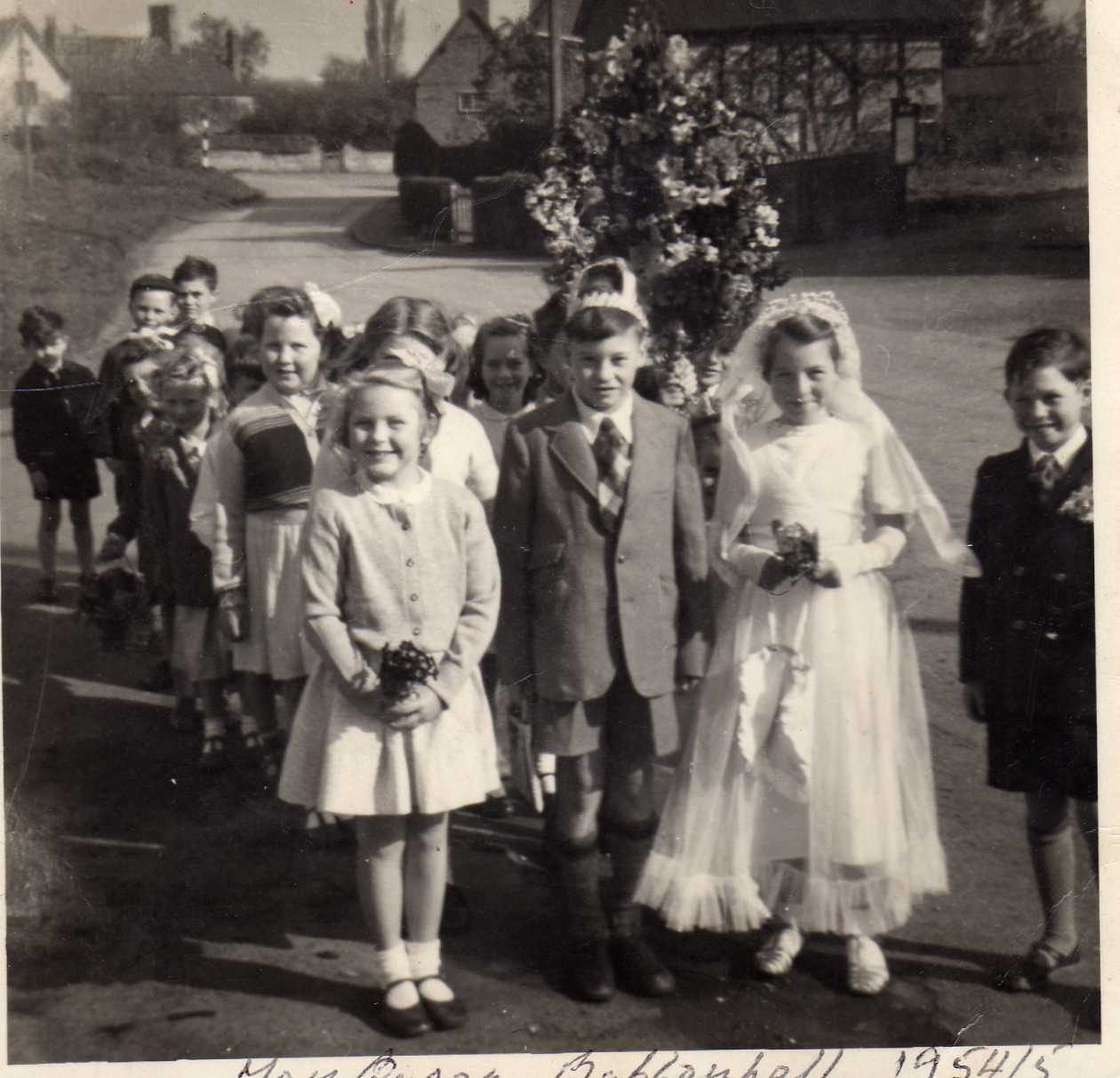
The May Day procession, c. 1954, when Judy Bennett was the May Queen.
The Wakes were held
on the first Sunday after St. Giles' Day, 12th September. These ceased
during World War I. They were held on the Green and on Pit Hill and down
the main street. There were Swingboats on the small green opposite The
Cottage in the middle of the village, and roundabouts at the bottom of
Pit Hill. An old sword was used by someone who was blindfolded to cut
at a side of meat. The women used to chase a greased piglet and the one
who caught it won it.
Bowling for a Pig
was often a feature of village fetes and church bazaars after the Second
World War.
The Wroth Silver Ceremony
is held on Martinmas Eve, 11th November, on Knightlow Hill, the meeting
place of the parishes of Knightlow Hundred. Bubbenhall is one of 25 parishes
who contribute money by throwing it into an old hollow stone - 2 1/2d.
for Bubbenhall ( now a half penny?). After the ceremony before sunrise,
all repair to the Dun Cow at Stretton-on-Dunsmore for hot milk and rum,
and tobacco smoked in churchwarden pipes.
Skating: used to take
place on the pond on Pit Hill - the big end on the hill was used by older
children, and the little end extending onto the Green was used by younger
children
Local
dialect words:
Bread-and-cheese:
hawthorn leaves
Bacon-and-egg: bird's foot trefoil
Kack-handed: clumsy, or left-handed
Kek: cow parsley
Kid pile: bundle or pile of brushwood
Old lady: way of referring to very elderly women, e.g. Old lady
Carter (died c. 1954)
Rain pansy: heartsease
Robin's pincushion: a mossy, tuft-like growth on a dog rose,
with a reddish tinge
Sticking: groups of women went out collecting firewood together.
This was then loaded into old prams to take home
Snicket: a footpath between houses
Place-names:
The Enclosure Award (1726), a manorial estate map of 1809, and the sale
of the Baginton Estate in 1918 give us many local names, particularly
field names, which have now largely died out. 17th century documents relating
to the old perebendal estate give us more names - relating to the strips
or furlongs in the old open fields.
Darfield Hill and Darfield Close were farmed by the Busby family, whose
red sandstone tombstones stand in a row almost opposite the church porch.
Lambs Hill: Lammas land - reverted to common pasture at Lammastide on
1st August.
Moat Close: the close of land related to the old (moated?) farm at the
Bottom End.
Monk's Meadow : belonged to the Cistercian monastery of Stoneleigh and
later to Lord Leigh
Paget's Lane: the Paget family, who were in the 18th century connected
with Yew Tree Farm, and were allocated land near the way to Princethorpe
and Wappenbury.
(Does anyone know
where March Lane was?)
1918 to 1960
The period from the break-up of the old Baginton Estate in 1918, to 1960
- between the wars and in the immediate post-war period - saw the building
of the Council houses at the Bottom End at the beginning of World War
II (the plans were drawn in 1938 and 1939, including necessary road widening
to meet bye-law regulations), the building of houses near the Weston crossroads
in the Forties, and new homes on the Stoneleigh Road in 1945 and 1946.
A new rectory was also built in the early Fifties to replace the huge
19th-century one, which had been sold after the death of the Rev. William
Sneath in 1947. Otherwise this was a period of survival after the casualties
and shortages suffered by village families as a result of the two wars
and in the aftermath of the Coventry Blitz.
By 1945 the roof of
Old House Farm was caving in and the house was eventually bulldozed -
a new farmhouse having been built c. 1932-33 at the top of Pit Hill as
a modern and more comfortable replacement for the old house. The garden
railings of the old farmhouse remained for many years as an unofficial
bus stop for the Coventry bus service. At the same period, at the bottom
of the village, opposite the Moat, were more empty, broken-down cottages,
which were eventually demolished. There were also, at this time, dwellings
still in use but actually condemned as unfit for human habitation: three
half-timbered cottages in a row next to the Reading Room, demolished c.
1954 after the death of their owner, old Lady Carter; and nearby, "up
the yard", a number of late 19th-century tenements built in redbrick
round a narrow yard, demolished c. 1956. None of these sites was redeveloped
at that time.The village had begun to have electricity installed in 1934
by the Warwickshire Electric Power Company, but otherwise lacked the prerequisites
for development.
During the Fifties
the centre of the village achieved proper street lighting for the first
time. This was also a period of endless discussion at parish-council level
as to how funding might be provided to establish a Village Hall, the Reading
Room being a possible candidate. Meanwhile the hall at the back of the
Three Horse Shoes and the Village School were used for whist drives, bazaars,
and film shows.
Modernisation
and redevelopment from 1960
In
1960 work started on laying pipes for mains water. This meant that people
no longer had to rely on the spring ("the Spout") or the water
tapped from there to standpipes outside the Cottage, Yew Tree Farm, and
the Council houses.
Click here for an update on the Spout
Another essential facility, the sewerage scheme, was completed in 1965,
and at this point work was already underway on building fourteen new houses
and four old people's bungalows near The Moat at the Bottom End. From
this time onwards, when old houses and cottages regarded as being too
damp and uncomfortable for modern living were got rid of, new and often
high-quality houses were built in their place, e.g. Ashgrove and Malpas,
replacing old Pisford's Charity cottages, and The Riverside Bungalows
replacing the Mill. After many years of hard work and effort the
funding of the Playing Field was also achieved in the Sixties with the
purchase of Murcotts Ludgates. When the Post Office was established just
opposite the renewal of the Bottom End, now known as Lower End, took a
further leap forward.
Included in the sale
of the Manor House in 1966 were Woodbine Cottage opposite the butcher's
shop, and Town Barn, the field opposite Church House. Soon this former
Green Belt land was made available for the building of several large new
houses. The planning authorities of the Sixties and Seventies were open
to such developments, particularly in villages near Coventry and Leamington
providing dormitory accommodation for commuters and their families. Demolition,
conversion and extension of existing old properties led, for instance,
to the demolition of Church House outbuildings as a new housing site in
1973/74.
With the availablity
of suitable land at the beginning of the Seventies Bubbenhall's first
housing estate, Waggoner's Close/ Coopers' Walk, was built, thereby starting
the large-scale process of overlaying the medieval village pattern of
buildings and their adjoining closes, which had made up the middle of
the parish for so many centuries. A comparison between maps of the village
pre and post the development of Bryant's Estate shows this clearly.
Extraction of sand
and gravel from Waverley Wood Farm, including water extraction, also started
in the Seventies, and by the end of the decade a new access road had been
built to the site parallel with Weston Lane. Further sand and gravel extraction,
this time from former Glebe agricultural land, started in 1991. The village
was now no longer a farming community. Gradually the spring water at the
Spout was affected by the extraction industry and became unuseable, and
around the turn of the century the traditional village water supply had
dried up.
During the past thirty
years large and small-scale development has continued. Older properties
have been altered and/or extended. York Farm and Middle Barn and York
Barn have been renovated. Darfield Court has been built on the site of
Old House Farm. Building has also taken place on pieces of land released
for new houses, e.g. the land belonging to the butcher's shop in the lane
going down to the church. Until the latter part of the Sixties Church
Road only contained three dwellings, with cattle in Town Barn, the big
field opposite Church House, and the butcher's pigs in the field between
the shop and Church House - though the chestnut trees planted along the
lane by Mr. Cowley c. 1918 still stand. Perhaps one of the greatest achievements
of the past fifty years, though, is the building of the Village Hall next
to the Village Playing Field. Formally inaugurated in 1987, it is one
of the most essential facilities for Bubbenhall's new and growing population.
Buildings
Link to information about the Buildings in
the Village
|